|
Kalvesta East
East of Kalvesta, KS
Cimarron, Kansas 67835
County: Hodgeman
View details. 
|
FCC ID: 1031273
Tower Height: 195
Total AMSL: 2,784
|
|
|
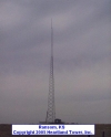
Ransom
South 1 mi. on Ness Co. RD 533.
Ransom, Kansas 67572
County: Ness
View details.
|
FCC ID: 1255034
Tower Height: 170
Total AMSL: 2,728
|
|
|
Jetmore
Jetmore, KS
Jetmore, Kansas 67854
County: Hodgeman
View details.
|
FCC ID: 1034789
Tower Height: 295
Total AMSL: 2,621
|
|
|
Moorman
NW of 160, 283 junction
Ashland, Kansas 67831
County: Clark
View details.
|
FCC ID: 1249797
Tower Height: 335
Total AMSL: 2,603
|
|
|
Kinsley
SW of Kinsley, KS
Kinsley, Kansas 67547
County: Edwards
View details.
|
FCC ID: 1251547
Tower Height: 335
Total AMSL: 2,523
|
|
|
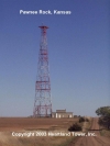
Pawnee Rock
1360 SW 40th Rd.
Pawnee Rock, Kansas 67567
County: Barton
View details.
|
FCC ID: 1032510
Tower Height: 306
Total AMSL: 2,456
|
|
|
Lexington
Lexington, KS
Ashland, Kansas 67831
County: Clark
View details.
|
FCC ID: 1250291
Tower Height: 335
Total AMSL: 2,451
|
|
|
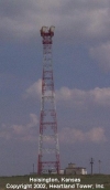
Hoisington
NE of Hoisington
Claflin, Kansas 67525
County: Barton
View details.
|
FCC ID: 1032507
Tower Height: 292
Total AMSL: 2,284
|
|
|
Protection
Protection, KS
Protection, Kansas 67127
County: Comanche
View details.
|
FCC ID: 1034797
Tower Height: 320
Total AMSL: 2,174
|
|
|
Matfield Green
7 mi East of Matfield Green
Matfield Green, Kansas 66862
County: Chase
View details.
|
FCC ID: 1032515
Tower Height: 393
Total AMSL: 2,079
|
|
